
As I looked up at Blanca Peak, I couldn't help but wonder about the adventure that was hidden within its rugged terrain. Little did I know, this mountain's history would intertwine with my own journey. There are a number of mountain peaks that exceed 14,000 feet in Colorado. 58 to be exact. The fourth-highest mountain in Colorado has held some significance, not only for me but for many others before me. To the Diné (Navajo People), this has been known as a sacred mountain and once served as a marker for the eastern boundary of their homeland.
It’s significant to others as they have loved ones who have taken their last breath somewhere on this mountain. From a basic search, you can find that someone dies here every year on average. I’ve driven by this mountain many times over the past seven years. I even had a failed attempt two years ago due to avalanche conditions being too severe. But, for some reason, Blanca Peak has kept calling me back. Was this going to be the year to make another attempt? Was it going to be successful?
The Call of Blanca Peak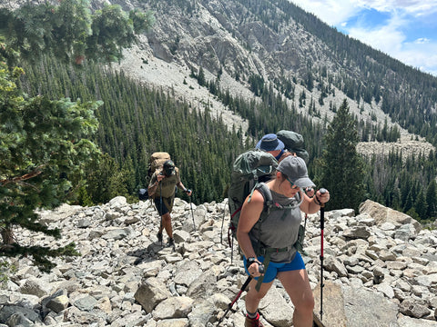 We began planning in late spring for another attempt at the end of July. Our plan was to drive up a portion of Lake Como road the first day, camp, and then start making our way up the mountain the following days. Lake Como Road is known as the roughest road in Colorado. However, I think most would consider that calling it a “road” is giving it more credit than it is worthy of.
Lake Como Road is an old mining road made of up some dirt, but mainly rock. Most four while drive vehicles can only drive a small portion of the length of this road. The road has lots of boulders and obstacles with nicknames like "Jaws" that have claimed the lives of off-road enthusiasts.
Along the hike, you can find evidence where things, unfortunately, didn’t turn out well for those who tried to drive this.
Only very heavily modified four-wheel drive vehicles and drivers with significant off-road experience can make it all the way to Lake Como. I know some will read this and think, “I bet I could make it.” Most likely not. Even if you have the vehicle capable, there are many areas where you wouldn’t want to put yourself at that risk.

Day 1 - Preparing the Ascent
On our first day, we arrived at the parking area right at the intersection of Highway 150 and Lake Como Road in the late afternoon. Depending on the time of year, you may see cars on the first stretch of Lake Como Road. Most vehicles with four-wheel drive will go up to about 8,000 feet and find a place to park. We drove up to around 9,000 feet where there’s a great spot for multiple vehicles to park. By the time we reached this area, it wasn’t getting far from dark and it was time to start prepping our gear to camp.
Day 2 - Movement to Base Camp
The next morning we’d begin packing up to start heading up to Lake Como. The distance from where we would start and end was around 3.5 miles. The amount of elevation gain across this averages almost 1000 feet per mile. This means you’re doing a lot of walking uphill. For those who are looking to hike this same route, be prepared to put in some work. Especially if you’re coming from a lower elevation like we were. As I’m writing this, my watch is telling me I’m at an elevation of eight feet. 3.5 miles sounds like a short distance but it’s generally not going to go by fast or without some effort.
Although it can be some work carrying a heavier ruck up this road, there are a number of amazing views along the way. In addition to walking through a beautiful wooded area. We took our time going up the trail and wouldn’t arrive at Lake Como until later that afternoon.

Lake Como is a beautiful alpine lake with clear water surrounded by mountains and forests.
It is an absolutely gorgeous place. When we arrived, I was surprised to see a few other tents. Especially considering that it was during the week. We were able to find plenty of room to ourselves on the other side of the lake which made it a non-issue though.
We set up our tents near a fast-moving stream that flowed into Lake Como which turned out to be a great water source for us. This would become our Base Camp for the next few days. After getting camp set up, we did a little fishing. Yes, I have a collapsable fishing pole that I was able to take with me. In an effort to minimize how much weight I was carrying, this and lures were the one luxury item that I would bring with me. Getting an out-of-state fishing license was relatively easy through the CO Parks and Wildlife website so I wanted to give fishing a try here. The water was clear enough that you could see a lot of trout swimming around. With just about every cast we were able to catch a fish. Oddly enough this turned out to not be as fun as you’d think. I wanted to spend more time fishing but you can catch your limit pretty quick. Regardless it has been a dream of mine to fish one of Colorado’s alpine lakes and it was an amazing experience even if short-lived.
(Longer video if you want to checkout as if you were there for a few minutes)
We’d later cook the fish we caught on a rock over our campfire which turned out to be great. There’s something great about catching fish and then eating it soon afterward that deeply connects you with your food and nature.

Just before the sun had set, we finished hanging our bear bags and came back down to camp. About that time we noticed several deer coming down off the mountain to graze in the meadow where we had our tents at. What an amazing end to the day!
Day 3 - Scaling the Summit
The next day we had planned to use as a day to spend around Lake Como for recovery and acclimation before going up any higher. However, with our base camp set, we geared up for the next leg of our journey. We decided to head out for the summit of Blanca Peak that day. We would leave a majority of our items at our Base Camp and head out with much lighter rucks. Even though we weren’t carrying a lot of heavy gear, it’s still important to take some of the basics in the event that something happens and you need to spend the night on the trail. The straight line distance from Lake Como to Blanca Peak is about two miles. However, sections of this leg of the trip would be by far some of the most difficult and you might add another mile toward the summit with the number of switchbacks you take.

Leaving Lake Como, the trail doesn’t initially have as much elevation gain as the previous day's hike. This made for an enjoyable start to the movement. Rising above the tree line you see a handful of other alpine lakes, a waterfall, and the potential for even more wildlife. When we first got above the tree line, I said that it “felt like being on another planet.” It just looked so different than what we had seen up until that point but it was amazing.
"For comparison, I completed a 100-mile race seven months ago, which I think most other people could do too. Summiting this mountain is not something I think most other people could do."

(Just below Crater Lake looking up at the saddle between Ellingwood and Blanca Peak)
The further you ascend, the bluer the lakes seemed to become. Large patches of snow that have survived the summer begin to reveal themselves. The highest lake, Crater Lake, is a gorgeous lake with a large rock protruding as if it’s its own small island. They say there’s no fish in this lake as it remains frozen solid for most of the year. However, we didn’t walk down to investigate further. Getting to the summit was our focus. Once we passed Crater Lake that’s when you really begin a steep ascent up the mountain. At this point, you’re less than a half mile from the summit but have about 1500 feet of elevation to gain.

(Just below the saddle looking down at Crater Lake)
Ascending the Treacherous Ridgeline
There are a lot of switchbacks to cover going up to the saddle between Ellingwood and Blanca Peak and this is where the trail becomes much harder to read. There are cairns along the way, but even still we had a hard time reading where the trail was. This probably led to a little more scrambling (using both hands and feet to climb) in this section than we should have been doing. I expected some scrambling on the final approach along the ridgeline to Blanca Peak but I didn’t expect to be scrambling so soon. It was relatively safe moving up to this saddle but at the same time if you happened to step/fall off the trail, it could result in a fatality. Every aspect of this trip required you to take it seriously but this area was even more so. For comparison, I completed a 100-mile race seven months ago, which I think most other people could do too. Summiting this mountain is not something I think most other people could do.
Upon reaching the ridgeline on the saddle is where your comfort level will really begin to be tested.... Part II Coming Soon.
Written by - CT August 2023